Background Information Old Testament New Testament New Testament (cont.) Gentile Period (cont.)
1-Biblical Jerusalem 16-Salem, Jebus 33-Ashlar Stones 51-Bethesda Pool 68-Saint Anne's Church
2-History of Jerusalem 17-Milo, Jebusite Wall 34-Temple Mount 52-Holy Sepulcher 69-Sultan's Pool
3a-Map of Today's City 18-Gihon Springs 35-NE of End of Wall 53-Garden Tomb 70-Citadel
3b-The Four Quarters 19-City of David 36-SE End of Wall 54-Fort Antonia 71-Colonnade Column
3c-Photos 20-David's Palace 37-Western Wall 55-Phasael Tower  
3d-Silwan 21-Temple Mount 38-West Wall Tunnel 56-Struthion Pool  
4-The Walls Today 22-Solomon's Walls 39-Mikvah, Ritual Baths 57-Gethsemane  
5-The Gates Today 23-Solomon's Quarries 40-The Large Mikvah 58-Tombs in Hinnom Miscellaneous
6-Archaeology Periods 24-Broad Wall 41-Wilson's Arch 59-Jerusalem Tombs Archaeological Finds
7-Archaeology History 25-Hezekiah's Tunnel 42-Warren's Gate Gentile Period Jason's Tomb
8-Old Ancient Core 26-Middle Gate 43-Barclay's Gate 60-Ecce Homo Lazarus' Tomb
9-Kidron Valley 27-Nehemiah's Wall 44-Robinson's Arch 61-Roman Inscription Tomb of David
10-Central Valley Hasmonean 45-Western Wall Street 62-Cardo Maximus Via Dolorosa
11-Hinnom Valley 28-Walls and Towers 46-Western Wall Shops 63-Roman Road Bazaars
12-Mount of Olives 29-Aqueduct 47-South Temple Wall 64-Nea Church Hezekiah's Pool
13-Mount Moriah 30-Acra 48-Archaeology Park 65-Al Aqsa Mosque Lachish and Assyria
14-Western Hill Mt Zion 31-Temple Mount 49-Siloam Road 66-Dome of the Rock .Ancient Artifacts, Period Pieces
15-Ophel 32-Tombs in Kidron 50-Siloam Pool 67-Temple Mount  
.............Generation Word Home Page ......................Jerusalem Site Map..................................Jerusalem 101 Home Page

63- Roman Road near the Western Wall Plaza


The Madaba map, a detailed mosaic from 542-570 found on a Byzantine church floor in Jordan, shows the location of the Church of the Holy Sepulcher, the Nea Church, the Cardo Street and much more. One the details portrayed on the Madaba map is another Roman street to the east of the main Cardo street, which has thus been called the Eastern Cardo Street. In 2007 a major colonnaded street running under the west portion of the Western Wall Prayer Plaza was uncovered during the early construction stages of a public service building. It appears the Eastern Cardo Street has been discovered. On the Madaba map this street runs northwest along the Tyropoean Valley to a place where it connects with
the Cardo street in a large paved area with a large Roman pillar in front of the Damascus Gate (which was known as the New Gate – i.e., Nea Gate – in the year 333 AD) in the north.

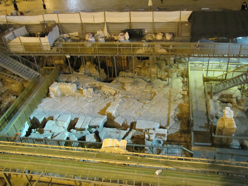
Notice the pavement in front of the Western Wall Plaza can be seen at the top of this photo. This helps identify the location of this ancient Roman, or Byzantine, Road


JERUSALEM: HISTORY, ARCHAEOLOGY AND
APOLOGETIC PROOF OF SCRIPTURE

Order Galyn Wiemers' 250 page book "Jerusalem" from
the many online booksellers at Amazon.com HERE

Download a FREE online .pdf of "Jerusalem" HERE

(click on the book cover to download the book as a .pdf )


For Bible teaching audio, video and study tools
visit Generation Word's home page at
www.generationword.com

Visit Generation Word Bible Teaching Ministry

Return to "JERUSALEM 101" home page