54- Fort Antonia |
Herod built a fortress on the higher bedrock in the northwest corner of the Temple Mount to keep an eye on activities and oversee the Jews in the Temple. He
named this stronghold Fort Antonia after his friend Marc Antony. The south wall of Fort Antonia was built in line with the north wall of the Temple Mount on an
outcropping of rock. This rockscarp can still be seen today protruding above ground level. The south wall of a Muslim boys’ school sets on this rockscarp on
the outside. Still remaining in this wall are about 26 Herodian ashlar stones, still in contact with the bedrock where they were originally placed. In addition to the
typical margins and bosses of the ashlars, a couple of interesting things can be seen in these blocks and on the rockscarp itself. In the rockscarp below the school
are two sets of sockets (notches cut into the rock to support a beam that extends out from the wall to support the roof of a structure):
- The lower trapezoidal sockets are in the photo (9 feet above the ground). They are from 661-900 AD and were made to hold the vaulting springs,
or beams of the roof, of a portico built by the Muslims at that time.
- 20 feet above them is a series of sockets 19 inches square, which held the massive roof beams of a majestic portico (or a covered colonnade) whose columns were 29 feet high. This portico, which Josephus says was 50 feet wide (War, 5:190), was built by Herod and went all the way around the Temple Mount.
|
|
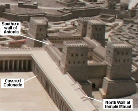
This is a model of the northwest corner of the Temple
Mount. Fort Antonia is outside, but shared the north
wall with the Temple complex, which then served as
Fort Antonia's south wall. The portico, or covered
colonnade, continued all around the inside of the
Temple Mount. At the south end, above the Double
Gate and Triple Gate, the covered colonnade became
a higher and wider section with four columns instead
of two. This area was known as Solomon’s Porch,
Solomon’s Colonnade, or the Royal Stoa. |
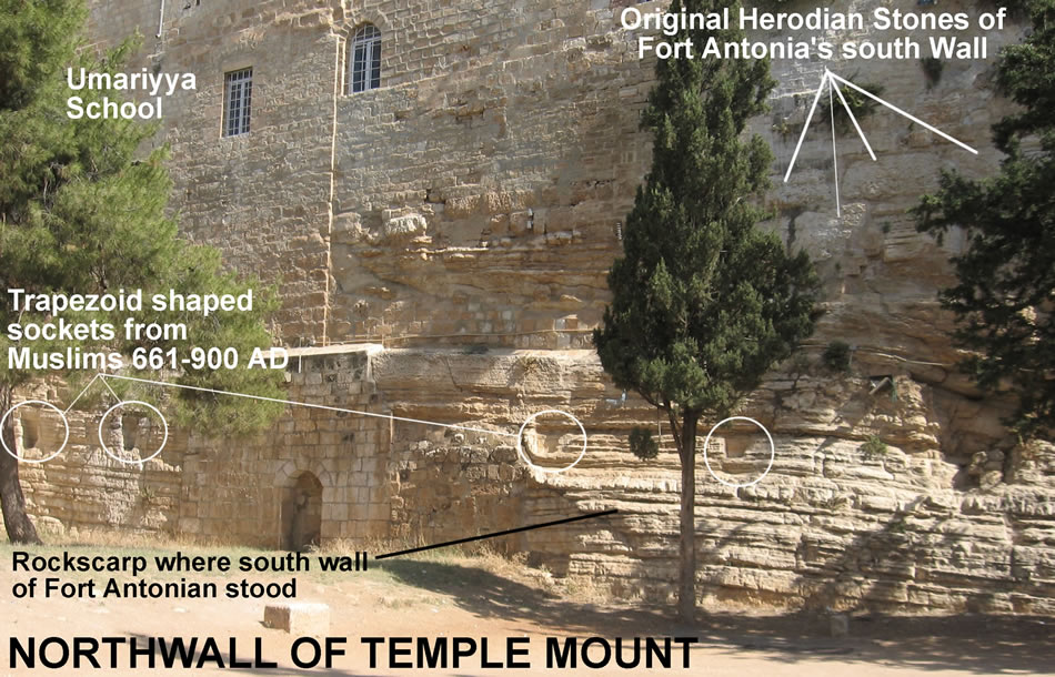 |
Fort Antonia, Herod's fortress used to oversee the Temple Mount, sat on this outcropping of rock that served as the foundation of the north wall of the Temple Mount. There are several things to notice in this photo:
- the outcropping of bedrock from Mount Moriah seen in the bottom right corner
- the remains of the original Herodian ashlars (about 26 remain) that were placed on the rockscarp and served as the outside of Fort Antonia’s south wall and also as the inside of the Temple Mount’s north wall.
- trapezoidal notches in the wall called sockets that were cut by Muslims at a later time for extended beams that supported a roof
- the current location of a Muslim boys’ school called the Umariyya School
- not visible in this photo but located east (right) of the Herodian ashlars are five or more 19- inch square sockets about 29 feet above the ground; these sockets supported beams for the colonnade that covered a pavement which ran around the inside of the Temple Mount walls in the days of Jesus and the New Testament.
The pillared portico, or colonnade (a walkway lined with columns and covered with a roof), would have run along the front of this rockscarp. The roof was supported by wooden beams extending upward from the 19-inch square sockets cut into Herodian ashlars 29 feet up the wall. The location and spacing of the columns can be identified by simply extending a perpendicular line out from the remaining 19-inch sockets. The wooden beams placed in these sockets would have lain on the columns, which would have
made them about 27 feet tall. The original Herodian paving stones from this colonnaded pavement were visible until recently, but they, like many other evidences of the ancient Jewish presence on the Temple Mount, have been covered up or removed by the Muslims. Even the trees growing along this wall block a clear view of the sockets. |
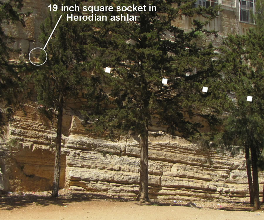
The first of five 19-inch square sockets that supported beams above the colonnade of the Jewish Temple is circled in one of the Herodian ashlars 29 feet above the ground. The location of the other four sockets, which are blocked by the trees, is marked by small white squares.
Below them, just right of the first tree trunk, is a trapezoidal socket cut later by Muslims. |

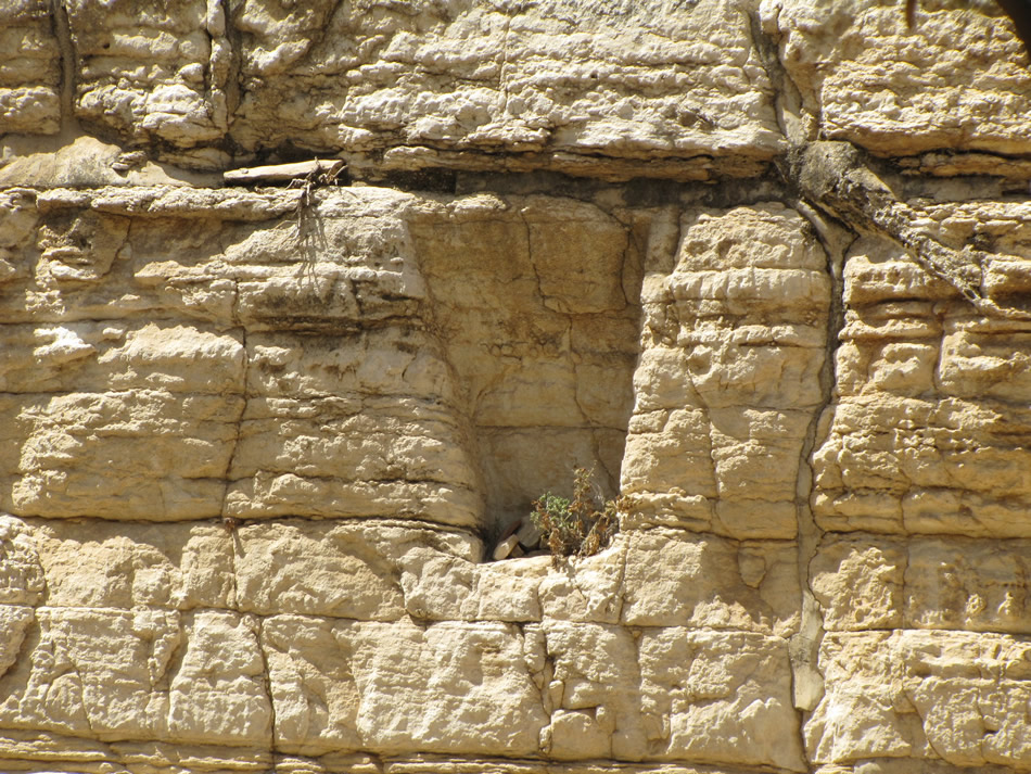
A close up of one of the 19-inch square sockets cut into the Temple Mount that was used to support a wooden beam that sat on the columns
and served as part of the roofing structure in the colonnade. |
Today, above the rockscarp is the Umariyya School, a Muslim school for boys. Herodian stones from the outside south wall of Fort Antonia can be seen in the
south wall of the Umariyya School. A 13-foot ancient wall can be seen inside the southern rooms of the Umariyya School. This thick wall would have been the
southern wall of Fort Antonia. To the east of the school is another building that still has six and a half feet of a Herodian pilaster, which would have decorated
the outside of the Jewish Temple Mount wall in the first century. |
One of the many sockets cut later in the rockscarp by Muslims. |
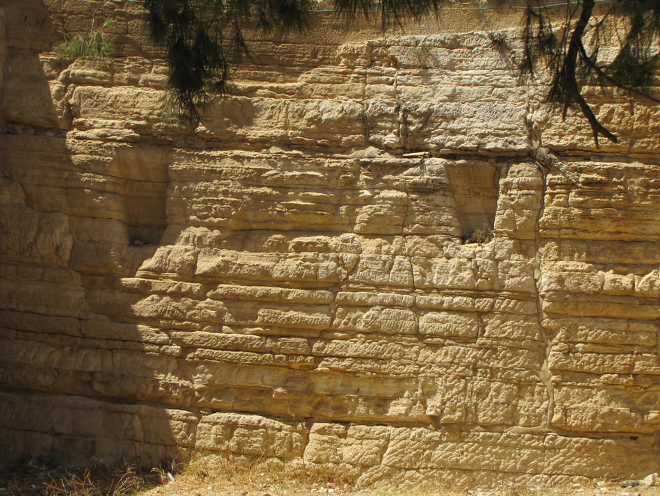
This is a photo of the trapezoidal sockets cut about 9 feet high in the bedrock. They were cut between 650 and 900 AD by Muslims to support wooden beams for one of the roof systems in their buildings.
|
| |
| |
| |
|