Background Information Old Testament New Testament New Testament (cont.) Gentile Period (cont.)
1-Biblical Jerusalem 16-Salem, Jebus 33-Ashlar Stones 51-Bethesda Pool 68-Saint Anne's Church
2-History of Jerusalem 17-Milo, Jebusite Wall 34-Temple Mount 52-Holy Sepulcher 69-Sultan's Pool
3a-Map of Today's City 18-Gihon Springs 35-NE of End of Wall 53-Garden Tomb 70-Citadel
3b-The Four Quarters 19-City of David 36-SE End of Wall 54-Fort Antonia 71-Colonnade Column
3c-Photos 20-David's Palace 37-Western Wall 55-Phasael Tower  
3d-Silwan 21-Temple Mount 38-West Wall Tunnel 56-Struthion Pool  
4-The Walls Today 22-Solomon's Walls 39-Mikvah, Ritual Baths 57-Gethsemane  
5-The Gates Today 23-Solomon's Quarries 40-The Large Mikvah 58-Tombs in Hinnom Miscellaneous
6-Archaeology Periods 24-Broad Wall 41-Wilson's Arch 59-Jerusalem Tombs Archaeological Finds
7-Archaeology History 25-Hezekiah's Tunnel 42-Warren's Gate Gentile Period Jason's Tomb
8-Old Ancient Core 26-Middle Gate 43-Barclay's Gate 60-Ecce Homo Lazarus' Tomb
9-Kidron Valley 27-Nehemiah's Wall 44-Robinson's Arch 61-Roman Inscription Tomb of David
10-Central Valley Hasmonean 45-Western Wall Street 62-Cardo Maximus Via Dolorosa
11-Hinnom Valley 28-Walls and Towers 46-Western Wall Shops 63-Roman Road Bazaars
12-Mount of Olives 29-Aqueduct 47-South Temple Wall 64-Nea Church Hezekiah's Pool
13-Mount Moriah 30-Acra 48-Archaeology Park 65-Al Aqsa Mosque Lachish and Assyria
14-Western Hill Mt Zion 31-Temple Mount 49-Siloam Road 66-Dome of the Rock .Ancient Artifacts, Period Pieces
15-Ophel 32-Tombs in Kidron 50-Siloam Pool 67-Temple Mount  
.............Generation Word Home Page ......................Jerusalem Site Map..................................Jerusalem 101 Home Page
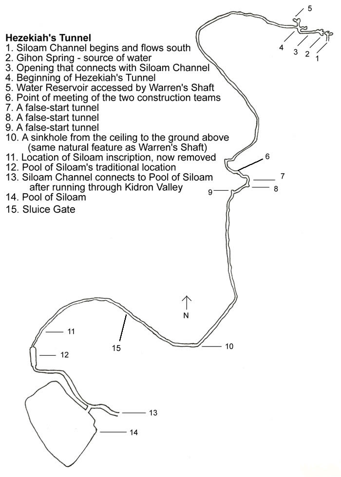
25- Hezekiah's Tunnel
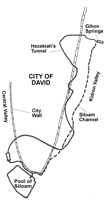
Warren's Shaft Pool of Siloam Tradional Pool of Siloam Siloam Channel
Hezekiah's Tunnel Sluice Gate    

Hezekiah's Tunnel - back to the top

Hezekiah’s Tunnel was cut through bedrock in 701 BC under the City of David, curving and weaving for 1750 feet. If the same tunnel were cut in a straight line, it
would be 40% shorter at only 1070 feet. This tunnel was designed and cut to bring water from the Gihon Springs in the Kidron Valley located on the east side
of the Eastern Hill outside the city’s walls, through the bedrock of the Eastern Hill to the west side, where Hezekiah’s city of Jerusalem was expanding and
protected by the new Broad Wall.

After all that Hezekiah had so faithfully done, Sennacherib king of Assyria came and invaded Judah. He laid siege to the fortified cities, thinking
to conquer them for himself. When Hezekiah saw that Sennacherib had come and that he intended to make war on Jerusalem, he consulted with his
officials and military staff about blocking off the water from the springs outside the city, and they helped him. A large force of men assembled, and
they blocked all the springs and the stream that flowed through the land. ‘Why should the kings of Assyria come and find plenty of water?’ they said.
Then he worked hard repairing all the broken sections of the wall and building towers on it. He built another wall outside that one and reinforced
the supporting terraces (Millo) of the City of David. He also made large numbers of weapons and shields. . . It was Hezekiah who blocked the upper
outlet of the Gihon spring and channeled the water down to the west side of the City of David. He succeeded in everything he undertook.
- 2 Chronicles 32:1-5, 30

As for the other events of Hezekiah’s reign, all his achievements and how he made the pool and the tunnel by which he brought water into the city, are
they not written in the book of the annals of the kings of Judah? - 2 Kings 20:20


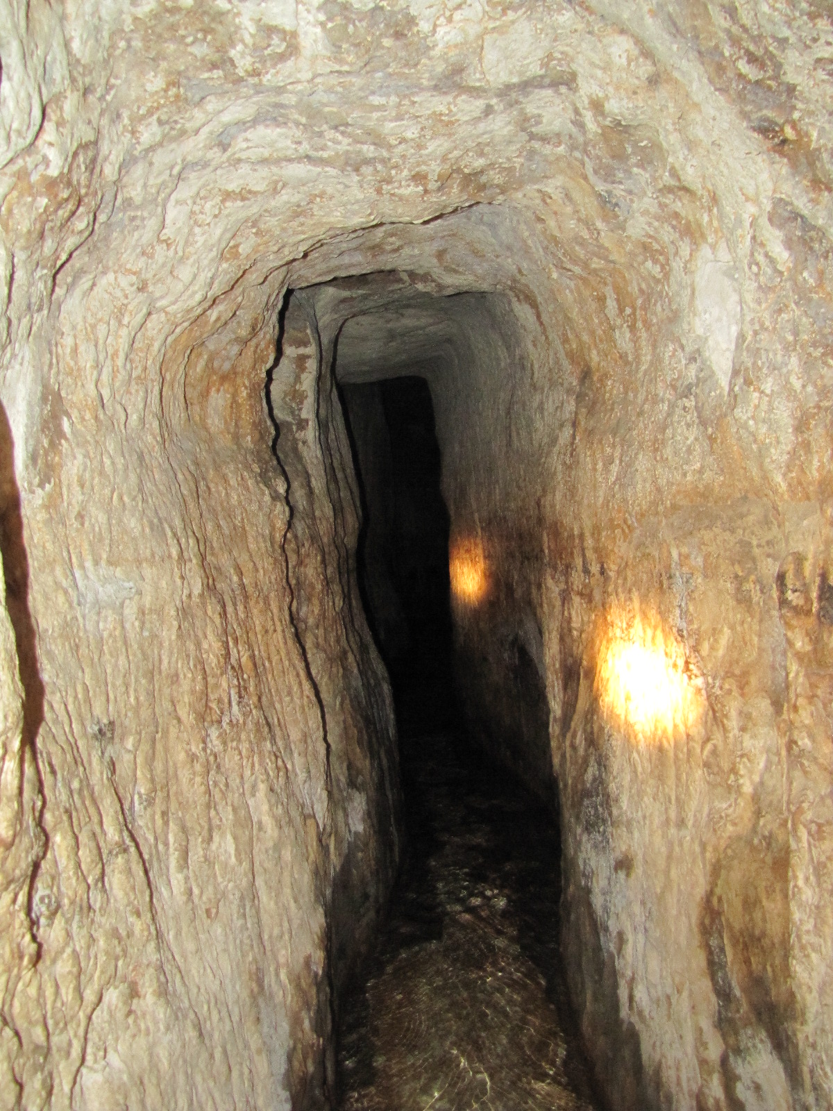
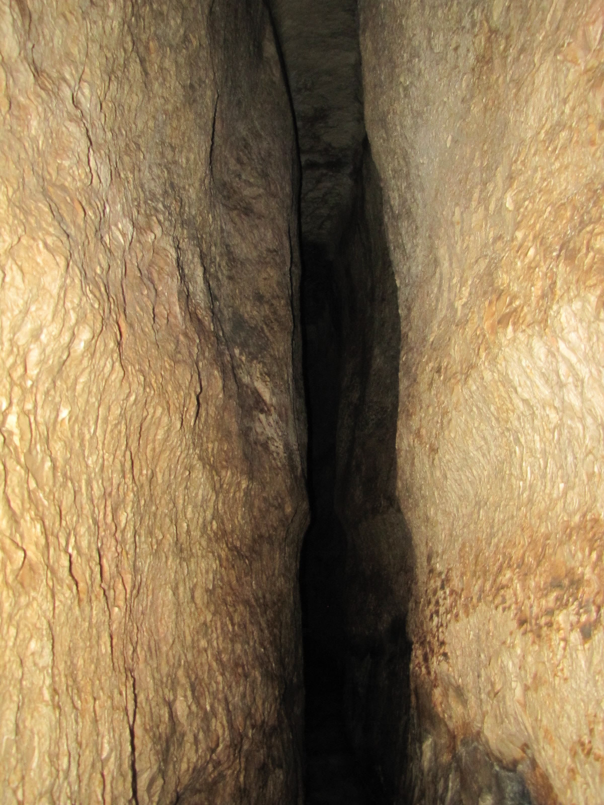
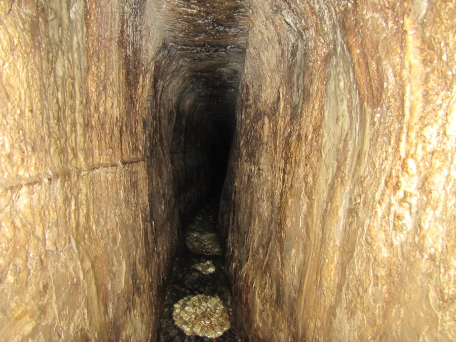
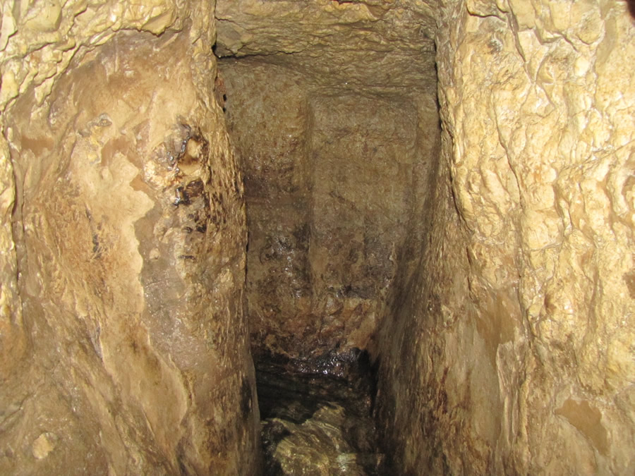
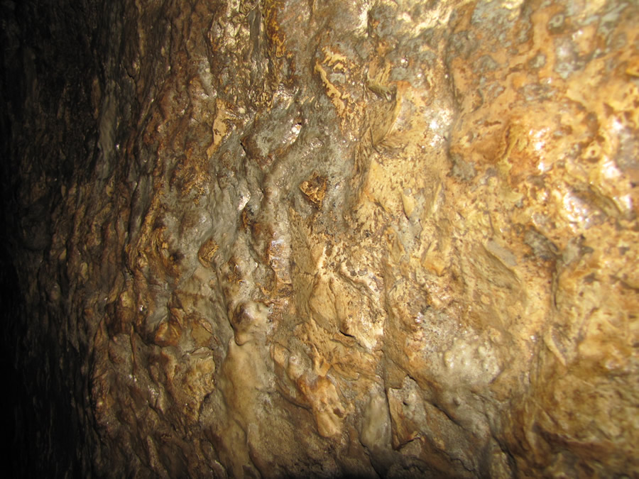
The pick marks of Hezekiah’s workers are still visible on the rock walls and ceiling of this 1,750 foot tunnel.

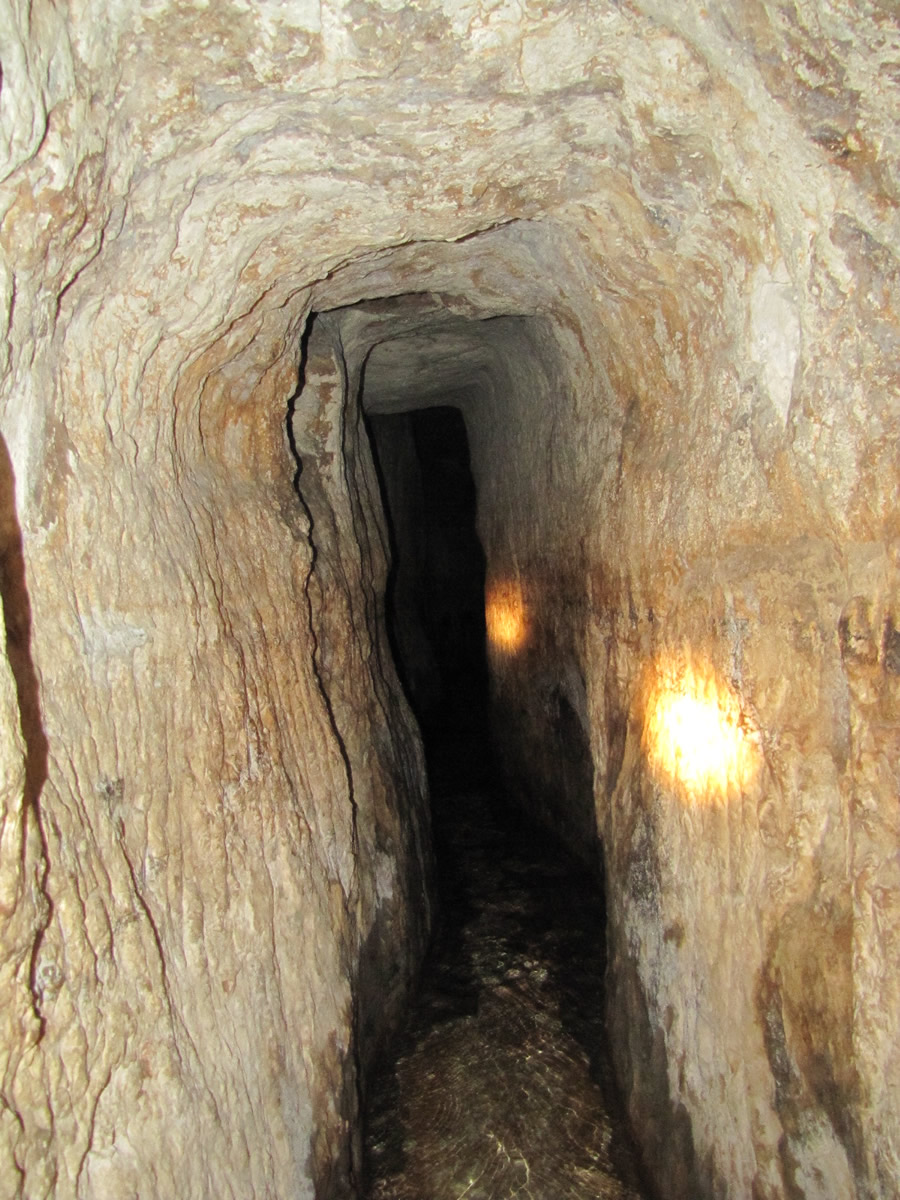
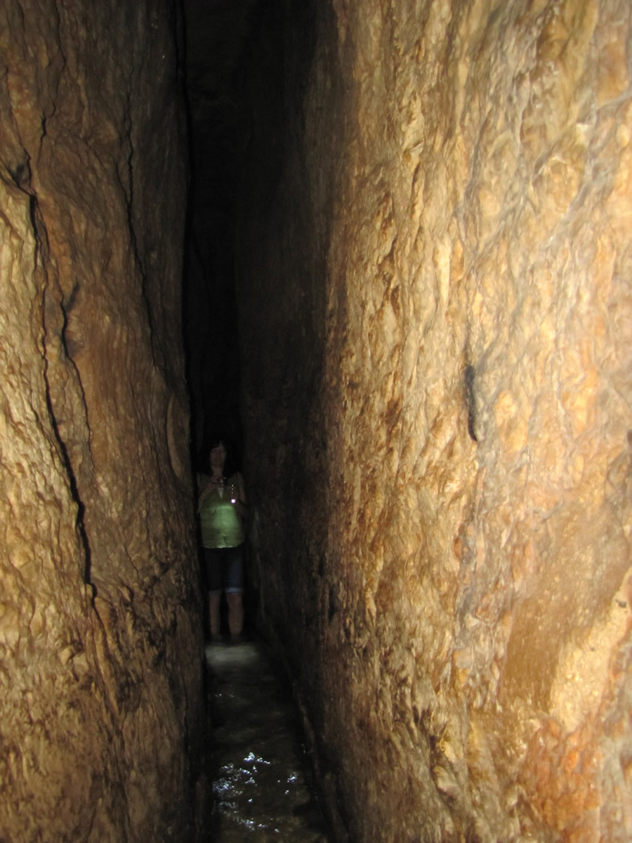
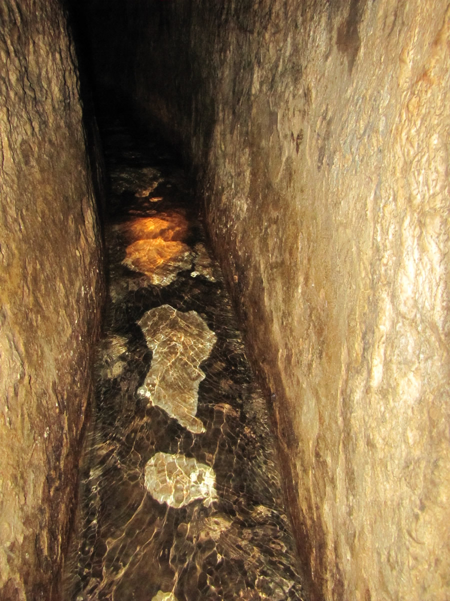
Hezekiah’s Tunnel is about 2 feet wide and 5 feet high at the entrance near the Gihon Springs, as seen in this photo. Notice the fresh water still moving through this tunnel as it has for 2,700 years.
 

Hezekiah Tunnel from Galyn Wiemers on Vimeo.

in gihon Springs Entering, tunnel that leads to Hezekiah's tunnel
In the Gihon Springs ready to enter the tunnel that leads to Hezekiahs Tunnel

in gihon Springs Entering, tunnel that leads to Hezekiahs tunnel
Photo of the same location as before, just in the dark with flashlights. In the Gihon Springs ready to enter
the tunnel that leads to Hezekiahs Tunnel.

The tunnel connecting the Gihon Springs to the beginning of Hezekiah's Tunnel

The beginning of Hezekiah's Tunnel
The beginning of Hezekiah's Tunnel.

Meeting point of the two crews in Hezekiah's Tunnel one from the north and one from the south meet with ledge, pick marks, false starts
A bend in the tunnel going left (south toward the Pool of Siloam) was made as the two crews of tunnelers were trying to meet each other. In this photo the impression
of the beginning of a straight tunnel can be seen in the tall, rectangular shape indentation. This direction was abandoned and the northern crew digging south from the
Gihon Springs turned left. The meeting place where the two crews met occurs just around this corner after a few more false starts.

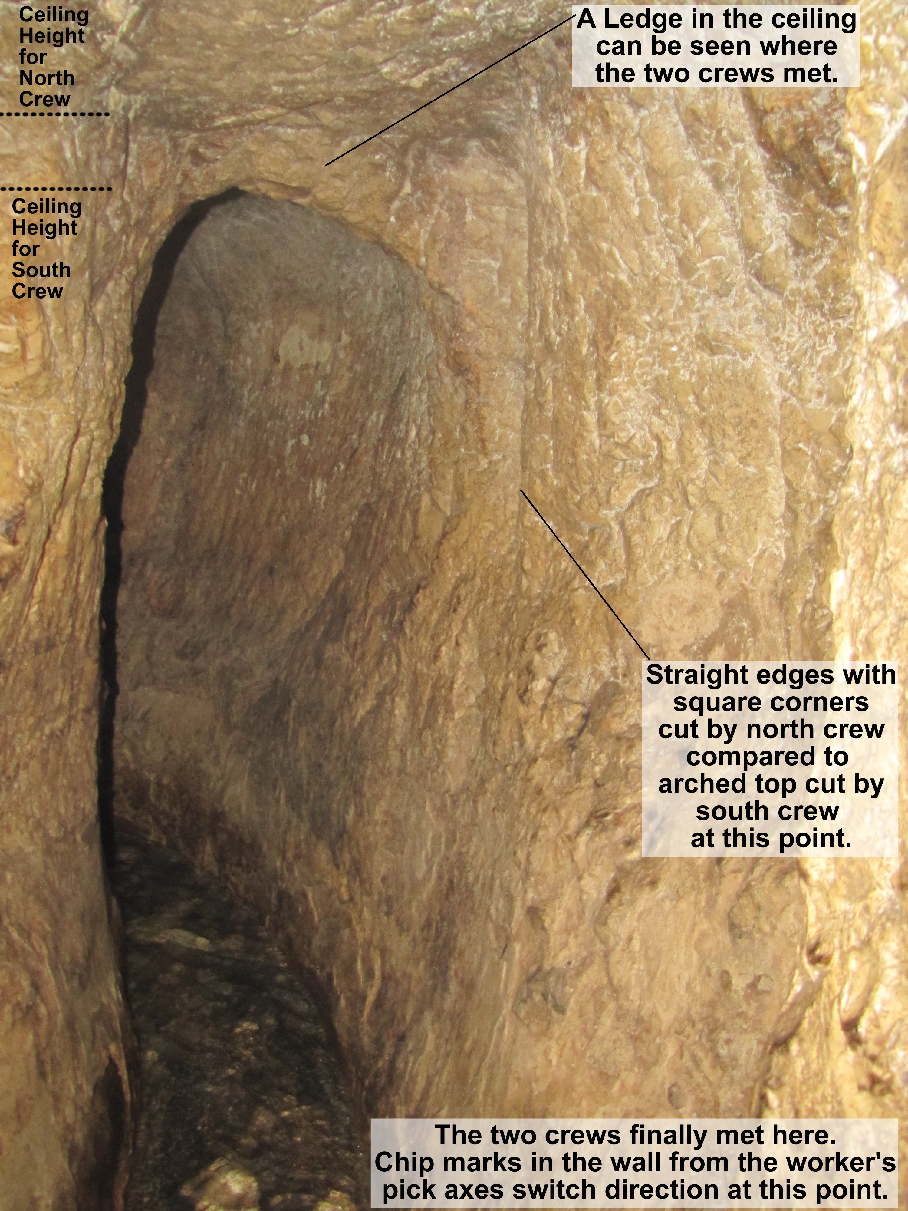
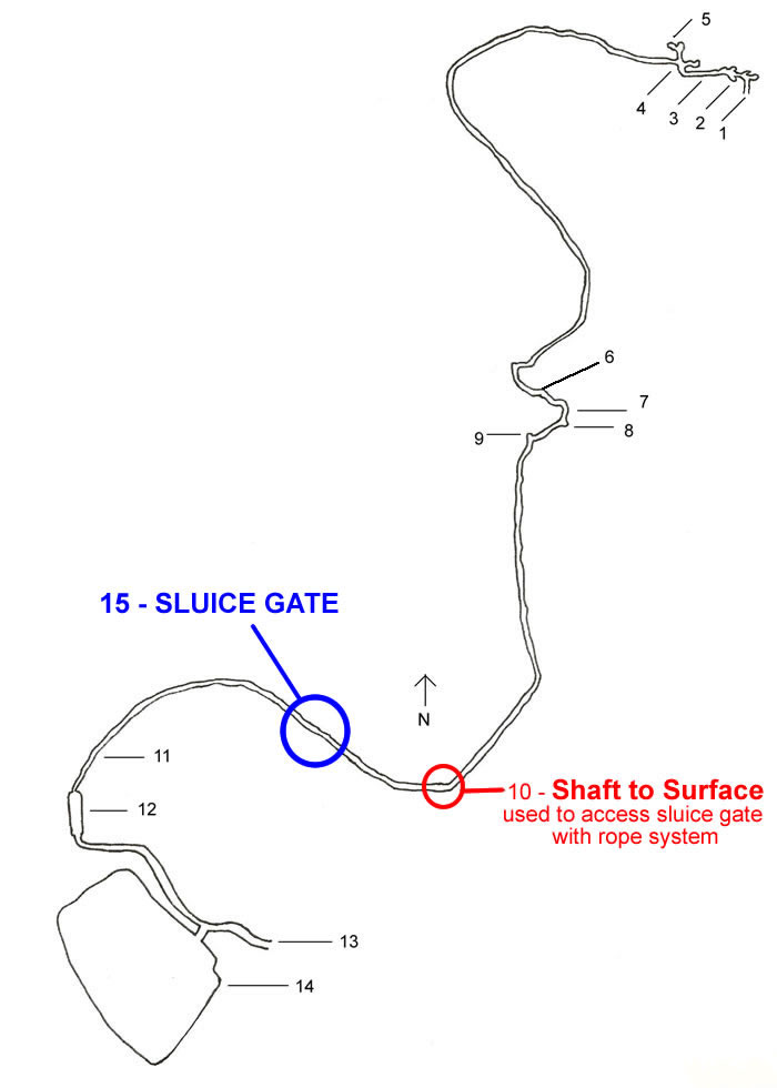
The point where the two crews finally met can be identified by at least three things besides the winding, weaving and false starts that proceeded it.
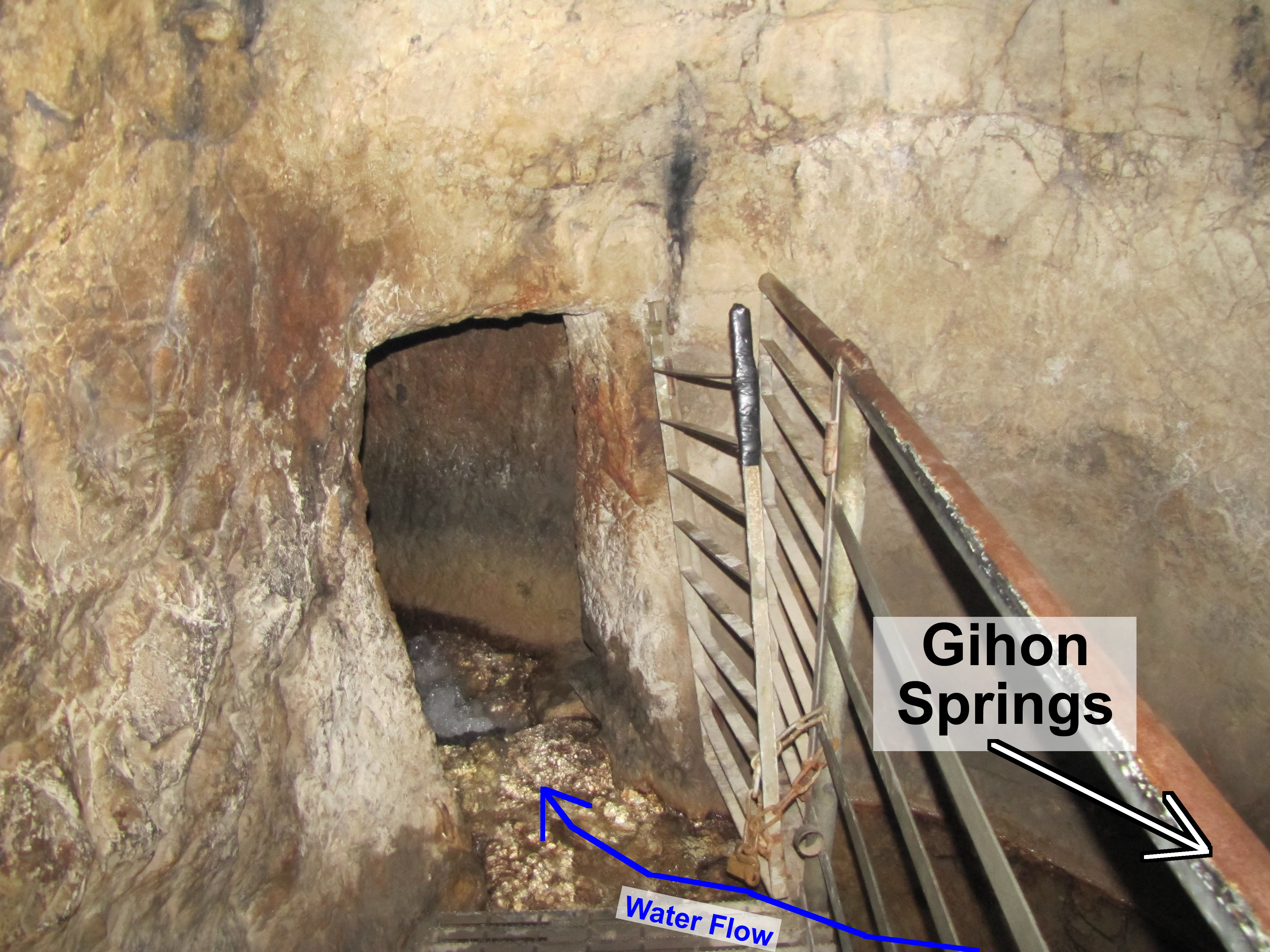
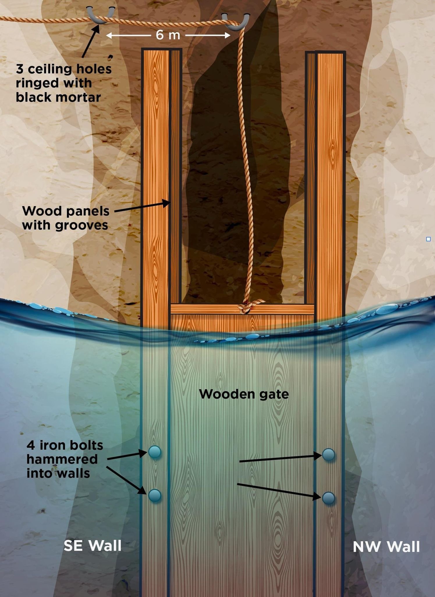
One, the ceilings are different heights at this point creating a ledge in the ceiling. Two, the tunnel from the north had square corners forming more of a rectangle shape
while the tunnel from the south had an arched top at this point. Three, the angle of the chips in the wall indicated the pick axes were being swung in
two different directions at the meeting point.

False start by one of the crews cutting the Hezekiah's Tunnel
A photo of one of the false starts that was abandoned and the direction of the tunnel changed in an attempt to meet the other crew.


Here the tunnels weaves to the right after passing by the point where the two crews met. In the walls the false starts, or the beginnings of wrong directions in the tunnel,
by the crew digging north from the Pool of Siloam can be seen in this photo. At this point the crews were attempting to meet each other so the water would flow from the
Gihon Springs through the tunnel to the Pool of Siloam.

Chiseled hole in the bedrock to hold a torch for light for the workers in the tunnel
Holes chiseled into the wall of the tunnel for the workers to set a torch to light the darkness as they worked undergrounded cutting through the bedrock.

Hole for holding torch or light in Hezekiah's Tunnel
Another hole in the wall to hold lighting for the workers.

Sluice Gate
In April of 2022 Aryeh E. Shimron, Vitaly Gutkin and Vladimir Uvarov released their extensive archaeological and scientific research in “Archaeological Discovery” (10, 69-113; https://doi.org/10.4236/ad.2022.102004) revealing evidence that a sluice gate was used in Hezekiah’s tunnel during and after the reign of Hezekiah (715-686 BC). A sluice gate is a movable damn that could be raised up to allow water to move through the tunnel to the Pool of Siloam or lowered to the floor of the tunnel creating a temporary blockage of the water flow moving south and instead fill up the original pools and channels on the north end that serviced the area around the Gihon Springs. These pools to the north included the pool accessed by the public through Warren’s Shaft, but there were other pools and channels in the Kidron Valley outside the eastern city walls. This portion of the water system near the Gihon Springs also provided water for the royal administrative building complex.

The Gihon Springs had abundantly provided water on the east side of the original city of Jerusalem (Salem, Jebus, City of David). But, with the diversion of the water from the Gihon Springs through Hezekiah’s Tunnel to the south into the Pool of Siloam the water supply to the north on the eastern side of the city would be drastically lowered. To control the water level at its source Hezekiah would need a plan to justify and monitor the diverting of the water to the other side of the city.

The resolution was the planning, installing and using a sluice gate along the route of Hezekiah’s Tunnel. This sluice gate would not only be politically acceptable to the citizens of the city by doubling available access to the city’s water, but it was also a strategically proactive military maneuver in preparation for the rising threat of an Assyrian siege. This very logic is recorded in a quote by Hezekiah’s team designing this tunnel:

Sennacherib king of Assyria came and invaded Judah and encamped against the fortified cities… And when Hezekiah saw that Sennacherib had come and intended to fight against Jerusalem, he planned with his officers and his mighty men to stop the water of the springs that were outside the city; and they helped him. A great many people were gathered, and they stopped all the springs and the brook that flowed through the land, saying, “Why should the kings of Assyria come and find much water?” He set to work resolutely and built up all the wall that was broken down and raised towers upon it, and outside it he built another wall, and he strengthened the Millo in the city of David. He also made weapons and shields in abundance…Hezekiah closed the upper outlet of the waters of Gihon and directed them down to the west side of the city of David. And Hezekiah prospered in all his works.”

  • 2 Chronicles 32:1-5, 30, ESV

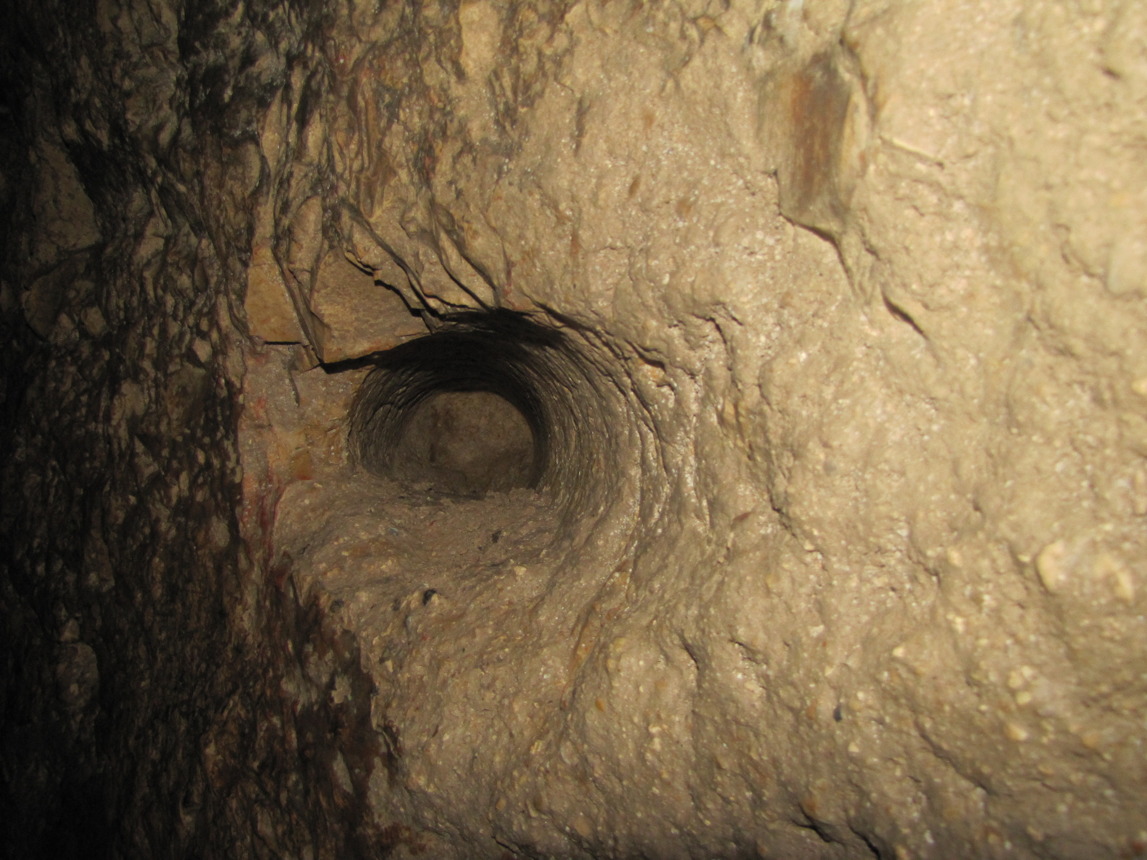
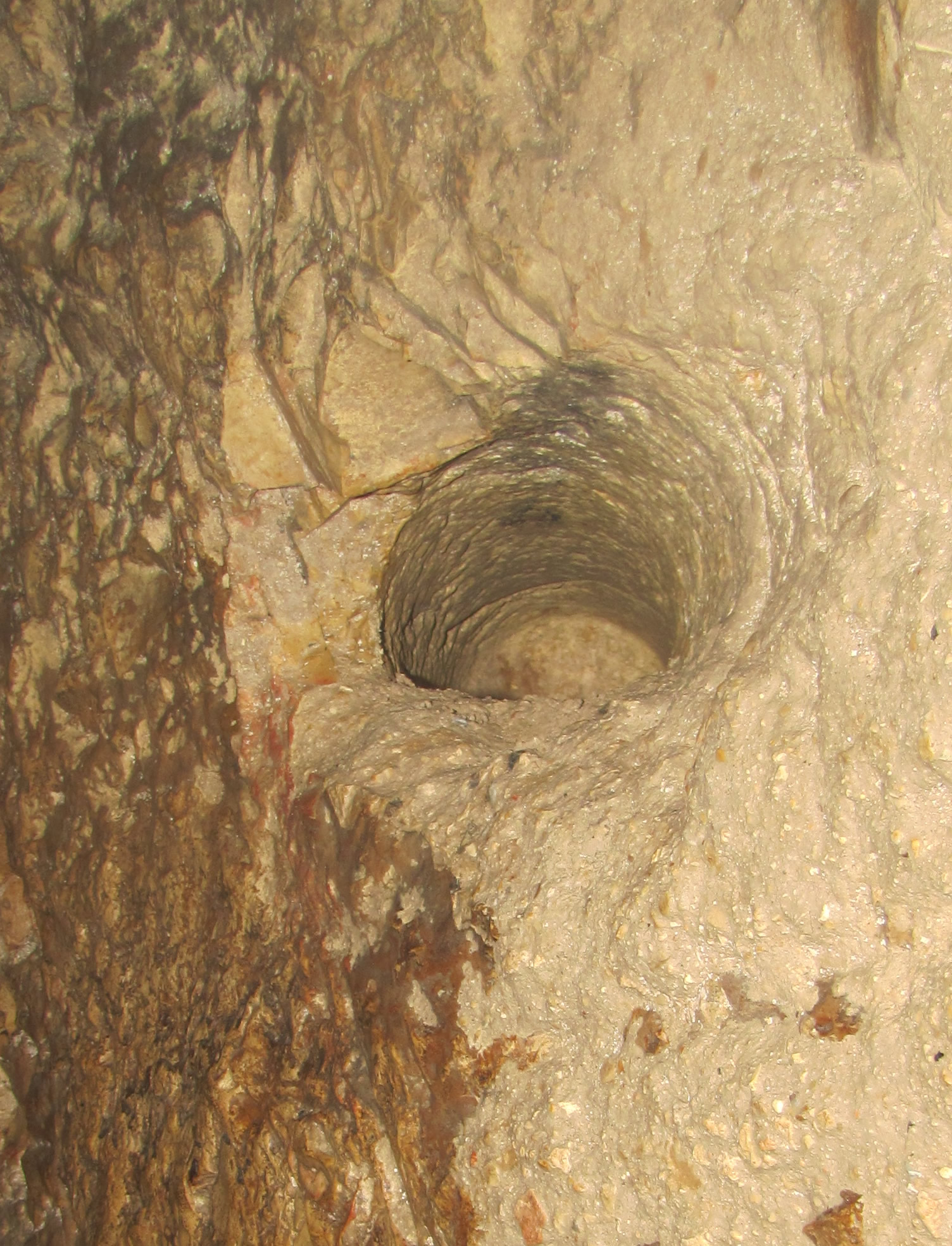
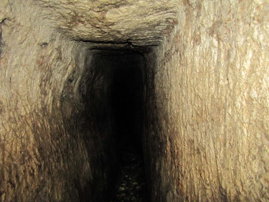
This device, the sluice gate, would control the water level in Hezekiah’s Tunnel while also allowing the pools on the north end of the tunnel to fill when the sluice gate was closed. But, also, when the sluice gate was open it would cut off the supply of water to the pools and channels outside the city walls that would be available to an attacking military.

The sluice gate was found to have been constructed 233 feet from the south exit of Hezekiah’s Tunnel. It is at this point evidence of a formerly functioning sluice gate is plentiful. Besides the logic that some form of control of the water supply for both sides of the city was an absolute necessity, there is evidence that this sluice gate did exist. There are signs of where it operated in the tunnel.

To make room for this tall, vertically-sliding gate to be raised up above the water level the ceiling would have to be cut higher than the 5-7 foot high ceiling cut south from the Gihon Springs. The point in Hezekiah’s Tunnel were the ceiling height goes from 6 feet to 19 feet is 233 feet from the south exit of the tunnel.

Sluice Gate in Hezekiah's Tunnel, 701 BC, iron bolts, cedar wood, sliding door to block, control water flow from Gihon Srpings

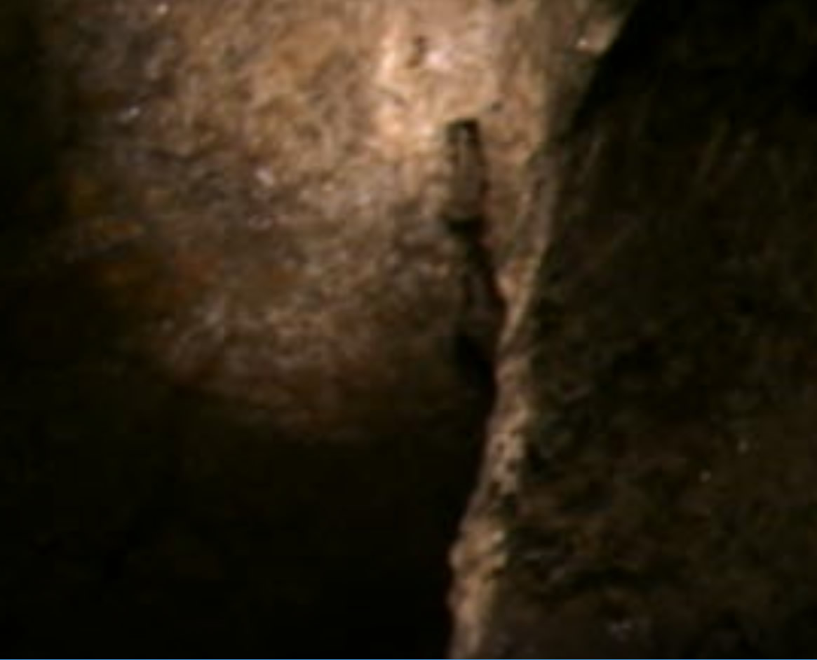
A few feet north of this point is a natural shaft (similar to Warren’s Shaft) that extends from the ceiling of the tunnel through a passage and then up and out to the surface above.
This was where a rope system would be installed to operate the lifting and lowering of the sluice gate. The location to operate the rope system on the surface above
Hezekiah’s Tunnel was inside the city walls and could easily be used during a siege. The rope system that controlled the sluice gate was protected inside the city walls
and it could be opened to draw all the water into the Pool of Siloam which would leave little or no water outside the city walls for the Assyrians.

There is also an indication of a metal device to guide the rope found in the traces of smelting ore that remain on the ceiling of the tunnel directly above the location of the gate.

Sluice Gate location diagram, map in Hezekiah's Tunnel
The location of the sluice gate and the shaft in the ceiling that continues to ground level are
shown in the above diagram of Hezekiah’s Tunnel.

The tall, vertical gate would have been made of wood (scientific examination indicates cedar wood) which would slide up and down in two wooden grooves,
one secured to each wall with two iron nails/bolts driven through the wood into the rock wall. The location of these nails/bolts are at this same point on each
side of the tunnel symmetrically placed two on each side below the location where the ceiling of the tunnel rises from 6 feet to 19 feet. 

Ceiling 19 foot, nineteen feet, high near end, second half, of Hezekiah's Tunnel, make room for Sluice Gate
Toward the end of the tunnel the ceiling reaches 19 feet high.

Iron nails of Sluice Gate in wall in 2007, video screen shot
Screen shot from a 2007 video Galyn Wiemers took in 2007 showing the two iron nails in the wall of Hezekiah's Tunnel
where the sluice gate was located.


The tunnel ceiling is only 5 feet high at the entrance, but reaches 16 feet toward the end, near the Pool of Siloam. The water is generally knee deep at the
beginning but only to mid calf throughout the rest of the tunnel. At times the water in the tunnel can be chest deep, depending on the circumstances.

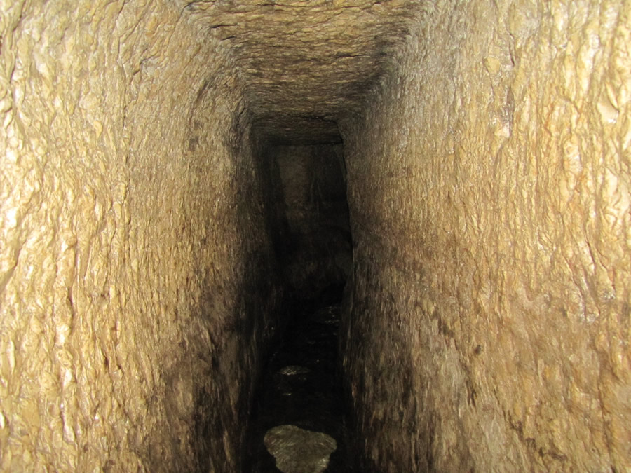
The water naturally flows from the Gihon Springs to the Pool of Siloam because the tunnel was cut using a 12 inch (0.6‰) gradient altitude difference between each end of the 1,750 foot tunnel.


A nice photo of the tunnel clearly showing the pick marks, the sharp corners where the walls and ceiling meet, and the fresh moving, cool water on the floor of
the tunnel which comes above the ankles to mid-calf.

The tunnel is 130 feet below the ground surface above on the Ophel.
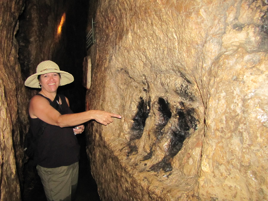
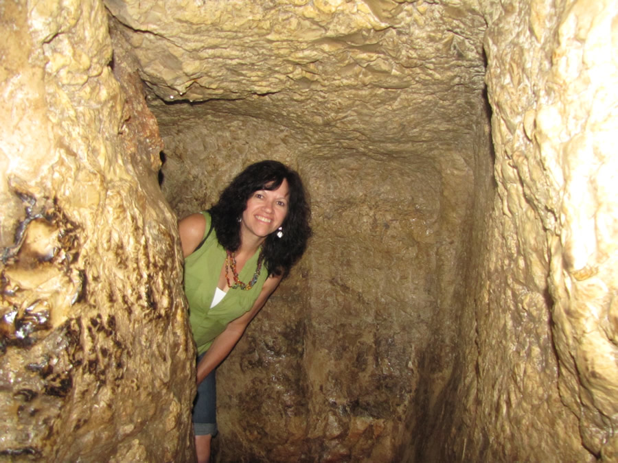

This tunnel was discovered by Edward Robinson in 1838 and was cleared by Montague Parker’s team during the years 1909-1911. The water had continued
flowing through this tunnel for 2,000 years. In fact, before its rediscovery, people thought the water in the area of the Pool of Siloam came from its own spring. It
was not until later that people realized the water in the Pool of Siloam is actually water from the Gihon Springs over a third of a mile away. Water still flows naturally
from the Gihon Springs today through Hezekiah’s Tunnel and to the Pool of Siloam.


A bend in the tunnel going left. The place where the two crews met.

Toni Wiemers
Toni in 2012


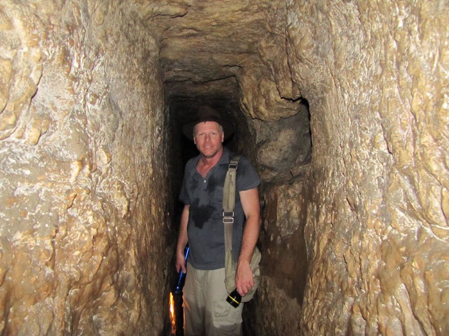
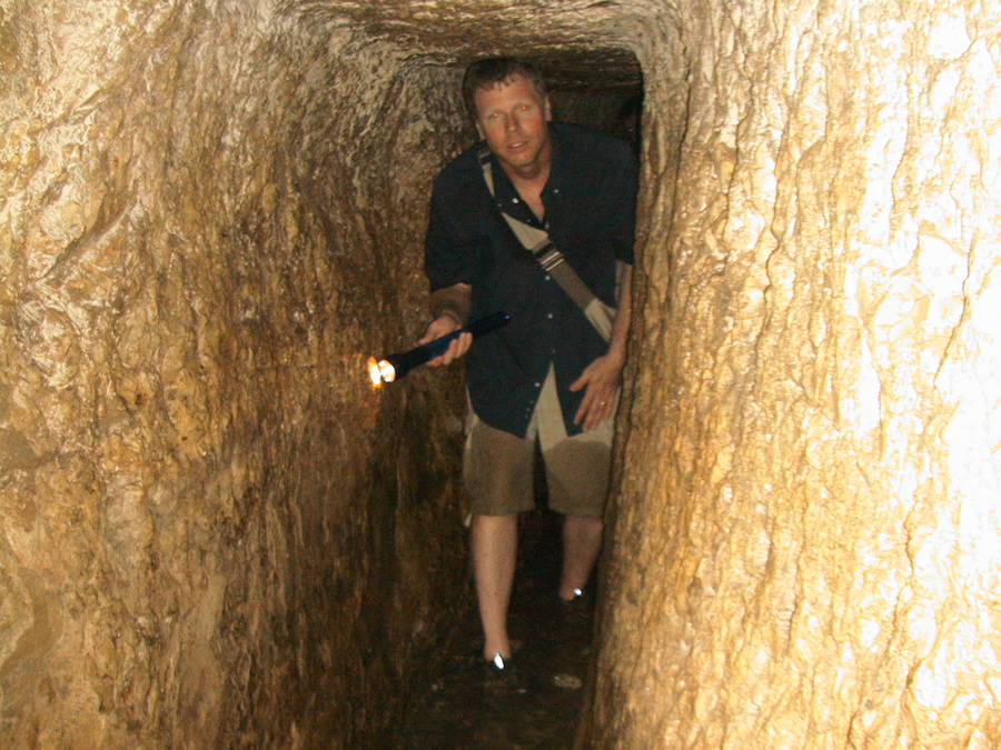
Galyn Wiemers in Hezekiah's Tunnel in 2007.


Galyn Wiemers in Hezekiah's Tunnel in 2010.


Toni points to the place where an inscription etched in the rock wall by Hezekiah's men was found in 1880. It is called the Siloam Inscription and was engraved in 701 BC. It describes how two teams of workers cut the tunnel, each coming from opposite ends, and when they met the water began to flow.


The Siloam Inscription was written in 701 BC and discovered in 1880. It was engraved in the wall of the tunnel, but later chiseled out of the bedrock and taken
to a museum in Istanbul, Turkey. Inscribed by one of Hezekiah’s workmen near the western end of the tunnel close to the Pool of Siloam, it reads:

[…when] (the tunnel) was driven through. And this was the way in which it was cut through: While [ . . .] (were) still [ . . . ] axes, each man toward his fellow,
and while there were still three cubits to be cut through, [there was heard] the voice of a man calling to his fellows, for there was an overlap in the
rock on the right [and on the left]. And when the tunnel was driven through, the quarrymen hewed (the rock), each man toward his fellow, axe against axe;
and the water flowed from the spring toward the reservoir for 1200 cubits, and the height of the rock above the heads of the quarrymen was 100 cubits.

- Siloam Inscription, engraved in 701 BC


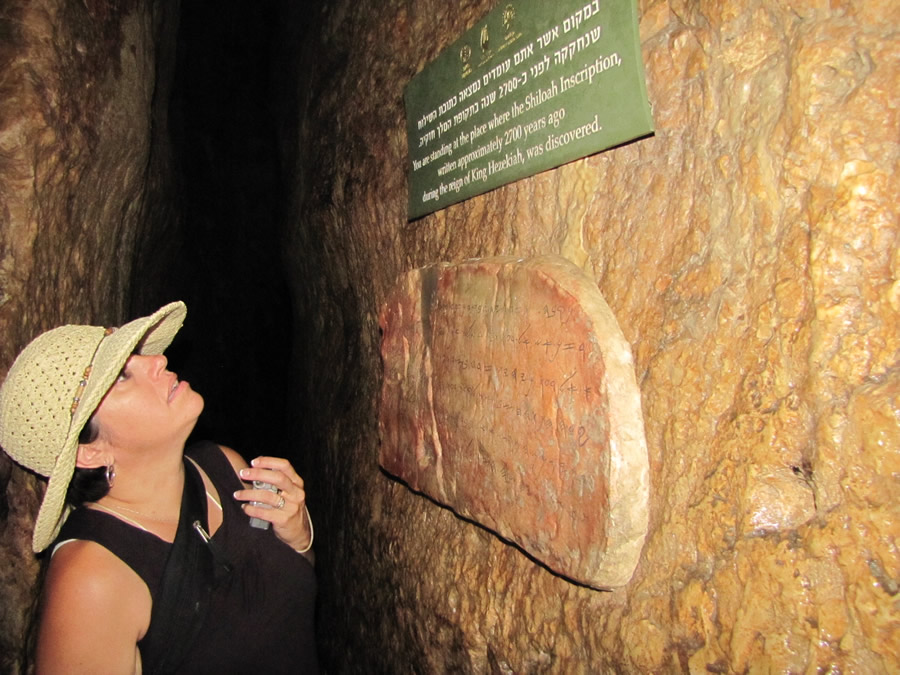
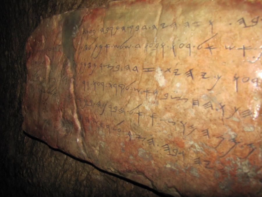
An imitation of the actual stone and the inscription that was removed and taken to a museum in Istanbul, Turkey.

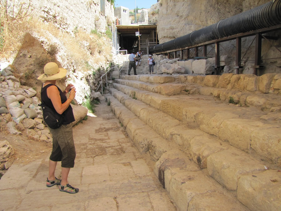
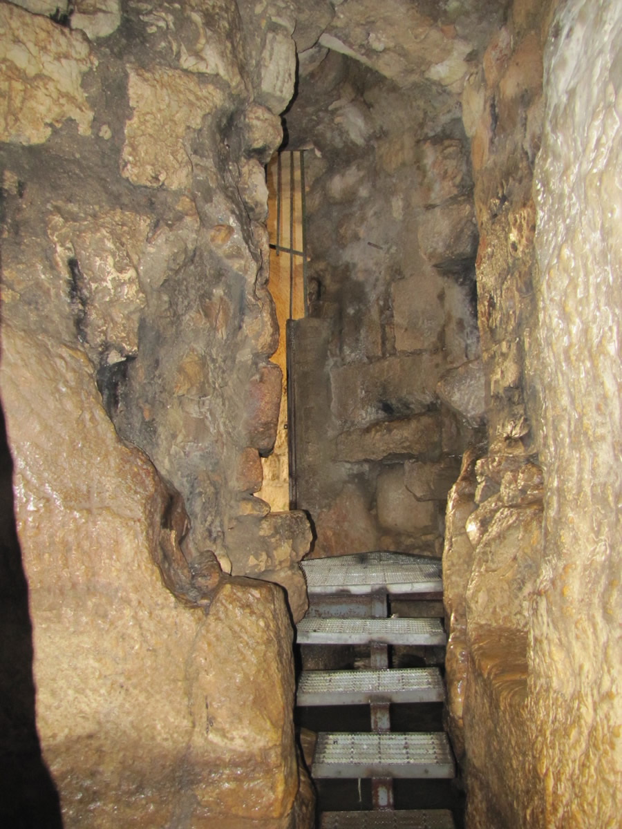
Stairs leading out of Hezekiah’s Tunnel to an open channel, through which the water flows into the Pool of Siloam.

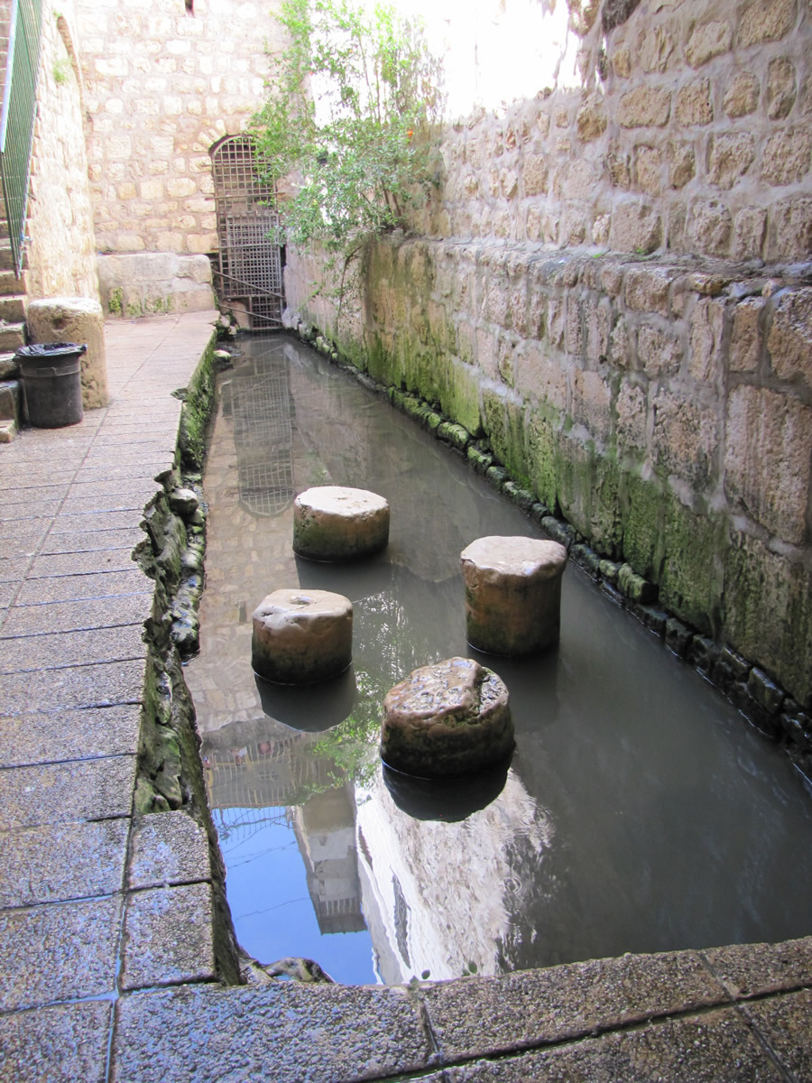
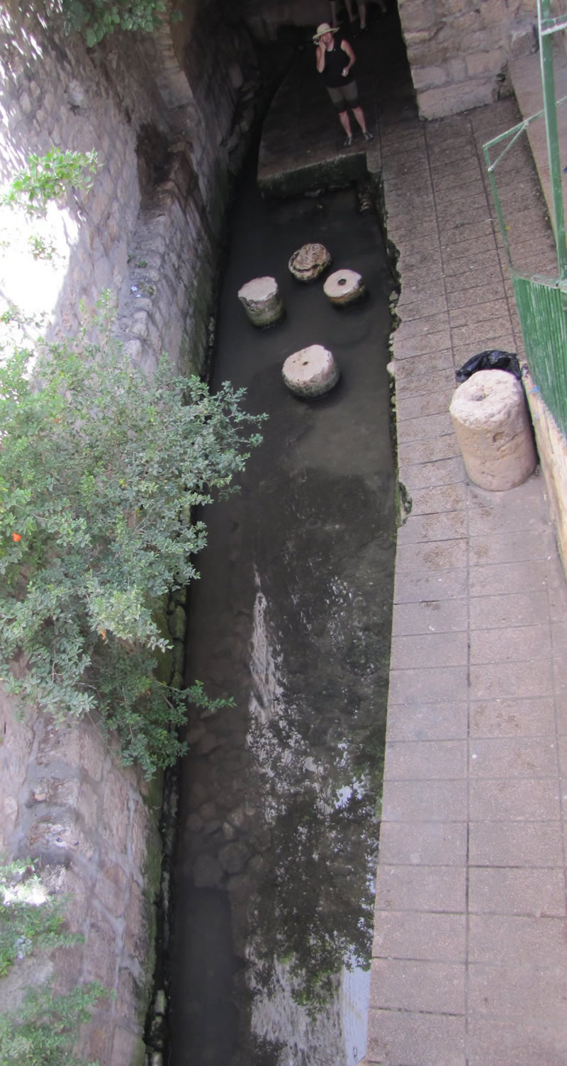
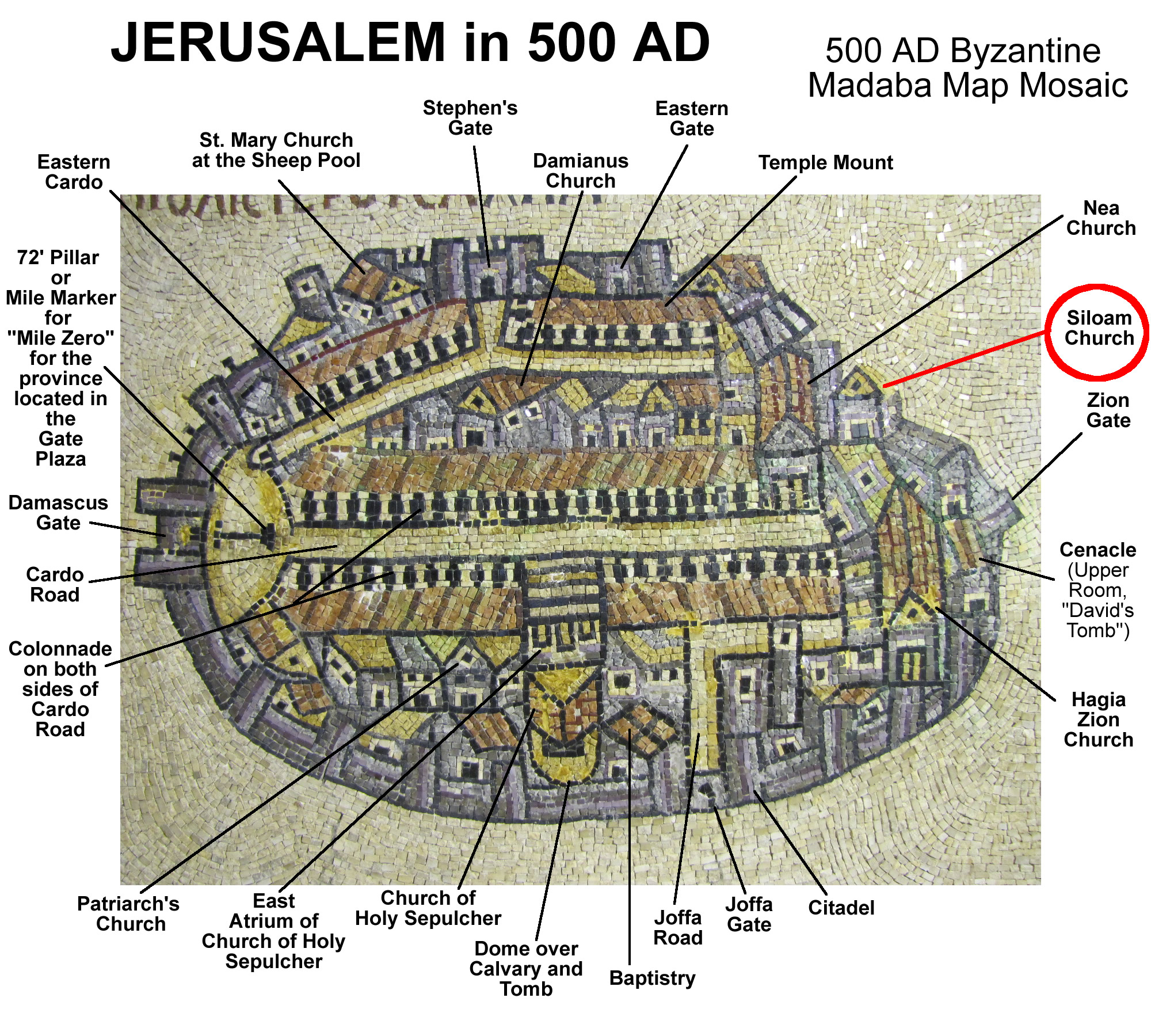
Siloam Channel - Traditional Pool of Siloam - back to the top


The water in the channel flowing out of Hezekiah’s Tunnel has been considered sacred and was believed to have healing powers. A church was built over the site
by the empress Eudokia around 450 AD. This church, along with most other churches of the Byzantine Empire, was destroyed in 614 when the Persians
invaded the Holy Land and Jerusalem. The remains of the bases of the pillars can be seen in the water of this open channel. The Bordeaux pilgrim, who saw
this location in 333 AD, wrote that this pool had four porches. In the 500’s, after the Church of Siloam was built by Eudokia, but before the Persians destroyed it,
a pilgrim from Piacenza wrote:

You descend by many steps to Siloam, and above Siloam is a hanging basilica beneath which the water of Siloam rises. Siloam has two basins
constructed of marble, which are separated from each other by a screen. Men were in one and women in the other to gain a blessing. In
these waters miracles take place, and lepers are cleansed. In front of the court is a large man-made pool and people are continually washing there;
for at regular intervals the spring sends a great deal of water into the basins, which goes on down the valley of Gethsemane (which they also call Jehosaphat)
as far as the River Jordan.

back to the top


A view of the open channel at the end of Hezekiah’s Tunnel. This channel flows into the Pool of Siloam.
The circular, or cylinder, remains of pillars are from a Byzantine church built on this site that was called the Siloam Church.

A view of the open channel from the exit of Hezekiah’s Tunnel. The Pool of Siloam is just a few feet on the other side of the gate that is seen at the end of the
channel. Until 2005, the channel was identified as the Pool of Siloam, but in 2005 the actual Pool of Siloam was uncovered accidentally by a city crew working on
the public sewer system. Today this water flows on toward that pool.

Madaba map showing the location of the Siloam Church at the end of Hezekiah's Tunnel.
The 500 AD Madaba Map of Jerusalem with the location of the Siloam Church built on the pillar stubs still seen in the channel at the end of Hezekiah's Tunnel.

Diagram of Hezekiah's Tunnel showing meeting location of crews, sluice gate, sink hole, siloam inscriptions


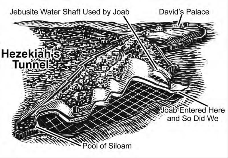
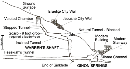
Warren's Shaft - The water from the Gihon Springs followed a natural tunnel to the base of a shaft discovered by Warren.
This shaft was developed from a natural sinkhole that extendeded down to the natural tunnel of water from the Gihon Springs.
City planners widened the sinkhole and developed a tunnel to reach it from the upper ground level of the city from within the city's walls.
Warren's Shaft functioned like a well. A person at the top of the shaft in the inclined tunnel could lower a bucket on a rope to the bottom
of the 38 foot shaft to get fresh water from the resevoir below. A person could reach this inclined tunnel by entering a vaulted chamber
from the ground level, walking down a steep, stepped tunnel, then use a ladder to descend a nine-foot scarp drop to arrive in the inclined tunnel.
The entrance to this water system was within the city walls, while the Gihon Spring was outside the walls.

Joab could have entered through Warren's Shaft, or he may have used the natural tunnel before it was blocked to access the inclined plane and ascend into the city.

back to the top

Hezekiah's Tunnel Diagram, Details

Pool of Siloam - back to the top


"Jerusalem: History, Archaeology and Apologetic Proof of Scripture - Revised Edition" 2022, Galyn Wiemers


UPDATED! 2022 -
JERUSALEM: HISTORY, ARCHAEOLOGY AND APOLOGETIC
PROOF OF SCRIPTURE - Revised Edition (2022)


Request a free copy of Galyn Wiemers' new, updated 311 page book "Jerusalem" by sending a shipping
address to gw@generationword.com

Open this link
(https://generationword.com/Jerusalem-History_Archaeology_Apologetic_Proof_of_Scripture-Revised_Edition-2022.htm)
to access links to download the Updated "Jerusalem" book
as FREE online .pdf files.

Access book files HERE.


JERUSALEM: HISTORY, ARCHAEOLOGY AND
APOLOGETIC PROOF OF SCRIPTURE (2010)

Order Galyn Wiemers' 250 page book "Jerusalem" from
the many online booksellers at Amazon.com HERE

Download a FREE online .pdf of "Jerusalem" HERE

(click on the book cover to download the book as a .pdf )


For Bible teaching audio, video and study tools
visit Generation Word's home page at
www.generationword.com

Visit Generation Word Bible Teaching Ministry

Return to "JERUSALEM 101" home page