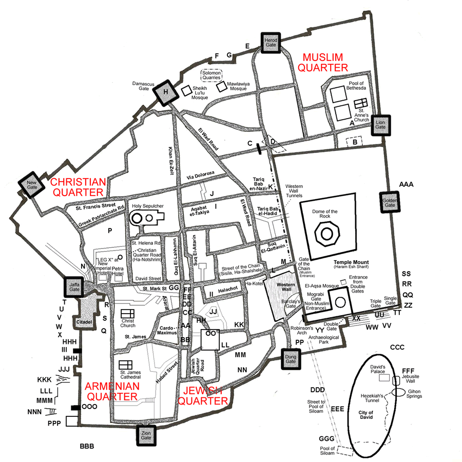
21- Temple Mount of Solomon |
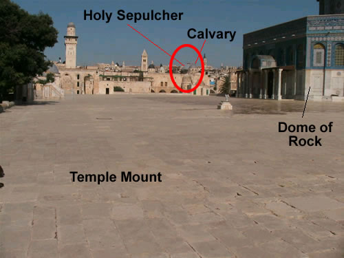
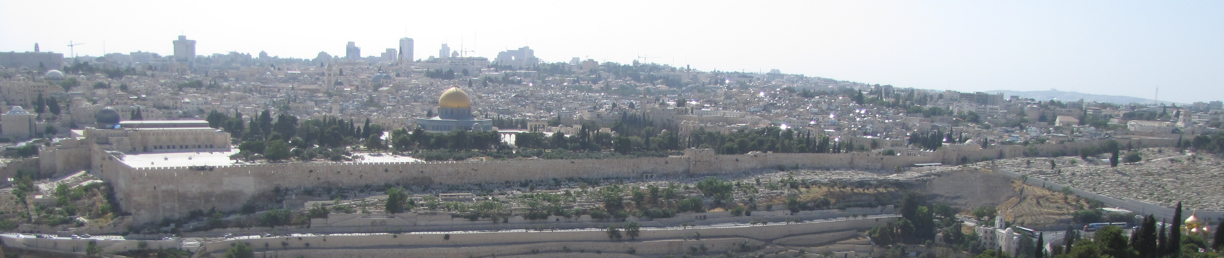
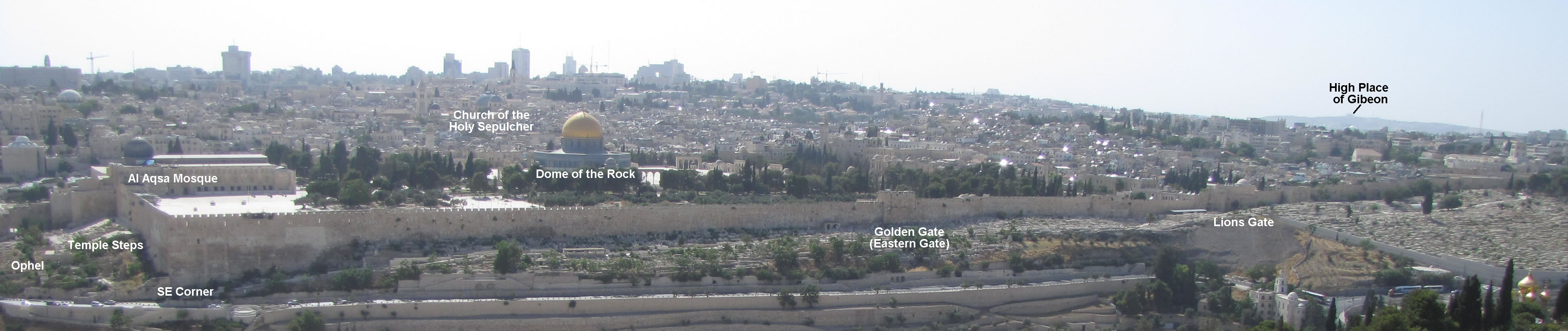
Below is a view of the Temple Mount from the Mount of Olives. The gold dome is the Dome of the Rock. The two gray domes slight to the left and behind the gold dome is the Church of the Holy Sepulcher. The building at the far left on the Temple Mount with the gray dome is the Al Aqsa Mosque. The Golden Gate can be seen in the eastern wall in about the middle of the photo.

>CLICK THE ABOVE IMAGE OF THE TEMPLE MOUNT TO VIEW A MUCH LARGE IMAGE!
>CLICK HERE FOR THE SAME LARGE IMAGE WITH LABELS!
|
David purchased the threshing floor north of the City of David from Araunah the Jebusite for 50 shekels of silver (2 Samuel 24:24) and paid 600 shekels
of gold for the entire site of Mount Moriah (1 Chronicles 21:25). These became the site of Solomon’s Temple. Interestingly, in recent Israeli-Palestinian
conflicts most Muslims around the world claim there was never an Israelite Temple on the Temple Mount. Solomon built the Temple that would sit on a square
Temple Mount platform on Mount Moriah. The Temple Mount platform was supported by retaining walls on all four sides which brought the surface area to a level
17 acres. Each of the retaining walls of the Temple Mount was 500 cubits long (or, 861 feet long using the conversion of one royal cubit to 20.67 inches).
In the four hundred and eightieth year after the Israelites had come out of Egypt, in the fourth year of Solomon’s reign over Israel, in the month
of Ziv, the second month, he began to build the temple of the Lord. . . . In building the temple, only blocks dressed at the quarry were used, and no
hammer, chisel or any other iron tool was heard at the temple site while it was being built. . . .The foundation of the temple of the Lord was laid in the fourth year, in the month of Ziv. In the eleventh year in the month of Bul, the eighth month, the temple was finished in all its details according to its specifications. He had spent seven years building it. – 1 Kings 1, 7, 36-38
|
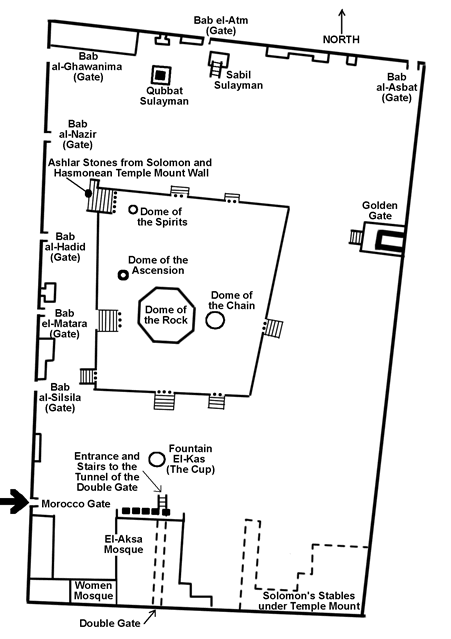
The layout of the Temple Mount today. The Mount of Olives would be to the right of this image.
The Dome of the Rock sets on a raised platform that is located on the large Temple Mount. |

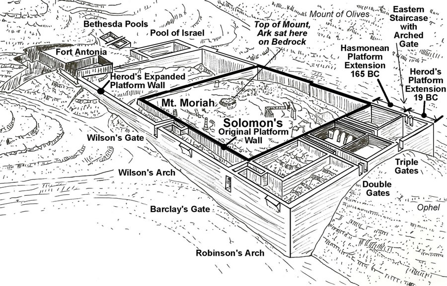
A view of the Temple Mount from the south. The Mount of Olives would be to the right of this photo. This is a diagram of the Temple Mount comparing the
size of Solomon’s 500 cubit square platform with the two later phases of extension. The first phase was in the days of the Hasmoneans who extended the
Temple Mount to the south; it is identified by a bend in the eastern wall were they began adding on. The second took place in 19 BC by Herod who extended it
even further to the south of the Hasmonean extension but also extended it to the west and the north. In all, Herod doubled the size of the Temple Mount.
|
View of Mount Moriah and the Temple Mount from the southwest corner. Notice how the top of the rugged Mount Moriah, which is the northern portion of the eastern ridge, was made into a large level surface. Solomon first built a 500 cubit square retaining wall around the high point of Mount Moriah. Then the area inside that square was filled in. The high point of bedrock that was left exposed was where the Ark of the Covenant sat and was the area that supported the Temple itself.
|
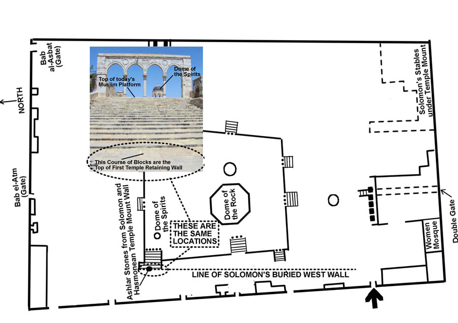
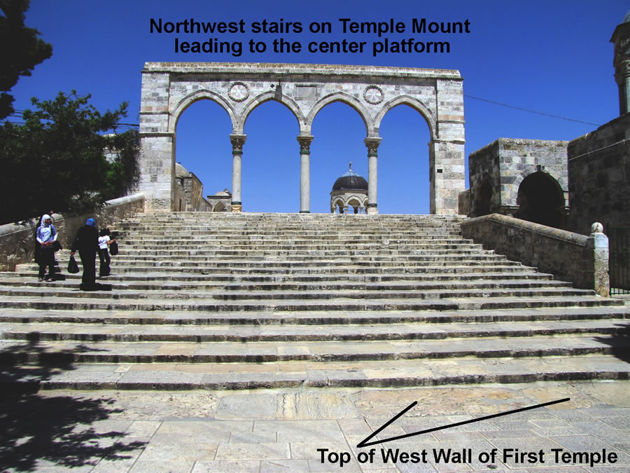
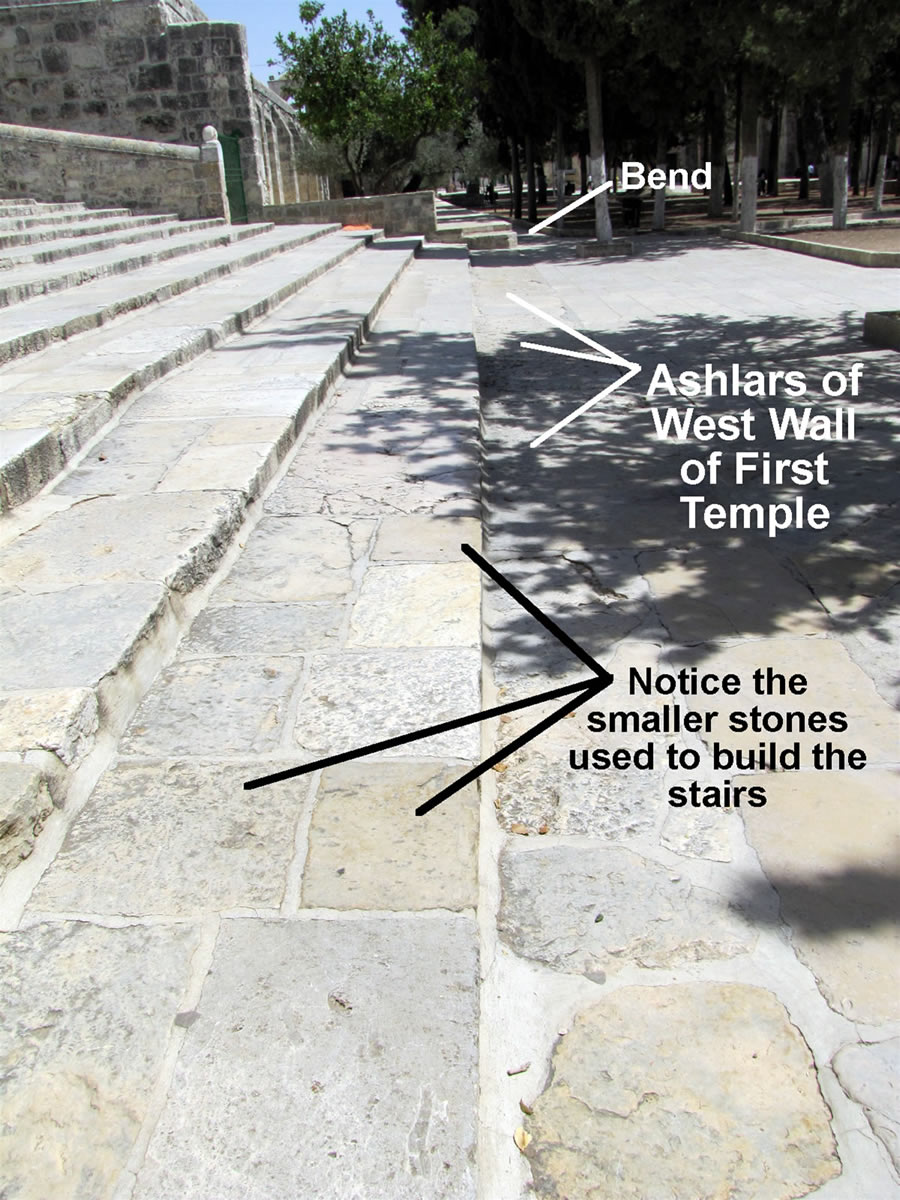
On the Temple Mount today a portion of the top course of cut stone that was in the line of the west wall of Solomon’s Temple can be seen, although Solomon’s Temple was destroyed in 586 BC by the Babylonians. Then beginning in 19 BC Herod the Great added additional retaining walls and fill to double the size of the
Temple Mount surface which buried any of Solomon’s outside retaining walls that remained. Today the Muslims have a raised platform that sits on the Temple Mount platform. This platform can be seen in the diagram above with the Dome of the Rock sitting on it. The stairs in the photo and in the bottom left corner (northwest) of the Muslim platform in the diagram are not perpendicular with the platform. Notice all the other staircases are perpendicular to the Muslim platform. Why are the northwest stairs at a different angle than the platform? There is a course of stones at the base of this northwest (bottom left) staircase whose top can be seen. These stones begin the angled staircase and instead running parallel with the Muslim platform, they preserve a former line of the west wall of Solomon’s 500 cubit square Temple Mount surface. The details of this information was collected and connected by Leen Ritmeyer who has assembled a very insightful and solid presentation on this subject in many of his writings, books and blogs including Secrets of Jerusalem’s Temple Mount and The Quest: Revealing the Temple Mount in Jerusalem.
This diagram has the east wall that faces the Mount of Olives at the top.
|
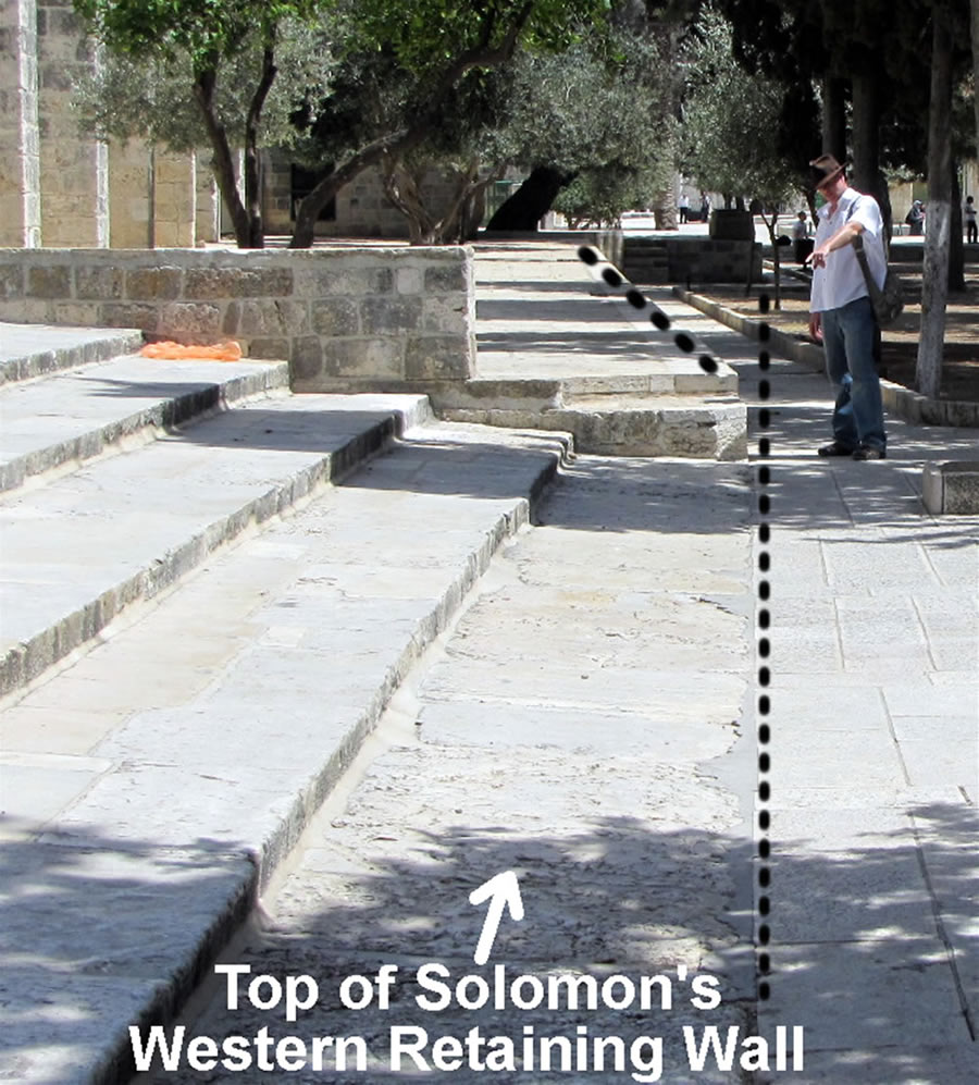
Galyn Wiemers points at the top of the course of ashlar stones that remain from the line of Solomon’s western retaining wall. On the stone closest to Galyn, the margin (the trimmed edge) and the boss (the raised center) of the face of the stone could be seen up until the 1970’s. At that time the pavement where Galyn is
standing was raised and mortar (which is visible in this photo to the left of the dotted line) was added to cover up the visible face, or outside, of Solomon’s western wall. Leen Ritmeyer has before and after photos of this alteration that he has published in his books and online.
|
| |
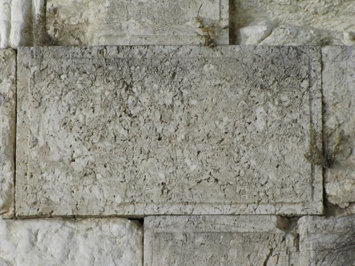
This is an example of a dressed ashlar stone from the time of Herod. Notice the raised boss in the center with the edges cut with
a two inch margin. This is the front of the stone in the Western Wall of Herod's Temple Mount. The stones seen from Solomon's
Temple are only visible from the top, but the cut margin and the raised center boss could be identified up until the 1970's when
they were covered with concrete or mortar.
|
The northwest stairway that is aligned with this bottom row of ashlar stones, instead of the top of the Muslim platform. The stairs are aligned with Solomon’s western retaining wall, which was buried by the Herodian addition to the west side of the Temple Mount.
|
 |
 |
 |
|